 Good evening to all.
Seeing the latest models and also past couple days, it looks like WARM and mostly sunny weather will continue through the work week with highs each day over interior lowlands looking to be in the low-mid 80`s with some upper 80`s also possible later in the week.
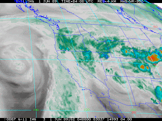
And our dry weather will be due split-flow aloft with high pressure in the GOA and a cut-off low(see satellite images) off the coast of California. Main affect from this low for the work week looks to be to convection over the Cascades of Oregon and perhaps WA as well, but convective parameters the last several days including today continue to favor the OR Cascades where instability will be the most favorable. But it`s also possible some convection could fire over the SW WA Cascades, but that continues to look like a small chance, though debris clouds could certainly drift northward over WA Cascades like they did this evening. Out cut-off low to the south looks to slowly drift southward over the next sever days and eventually weaken further and moving inland over California late in the week to which it then appears to move into the inner mountain west for the weekend with possible convection firing over higher terrain areas.
So over all, and though WARM, it looks like a really nice week ahead. A chance of showers might be back in our forecast for the weekend with highs being a bit cooler, though still mild, but also not as warm as to what we may see through Friday. So enjoy the early summer weather, but also take it easy, take breaks, cool off and put on that sun screen!


